





DeSantis Declares Emergency In 25 Florida Counties Ahead Of Possible Hurricane
Authored by Jack Phillips via The Epoch Times,
Florida Gov. Ron DeSantis on Tuesday evening declared an emergency for 25 counties ahead of Tropical Storm Isaias, which could strengthen into a hurricane in the coming days.
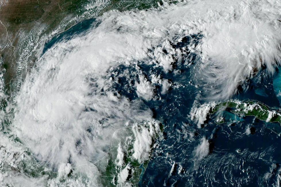
This satellite image from the National Oceanic and Atmospheric Administration shows Tropical Depression Nine forming over the Gulf of Mexico on Oct. 6, 2026. NOAA via AP
DeSantis said the order would allow the state emergency agency "to stage critical preparedness resources and ensure Florida is ready to respond," adding that residents "should take this time to get disaster plans in place and ensure their hurricane supply kit is stocked."
The order was issued for Baker, Bay, Calhoun, Columbia, Dixie, Escambia, Franklin, Gadsden, Gilchrist, Gulf, Hamilton, Holmes, Jackson, Jefferson, Lafayette, Leon, Liberty, Madison, Okaloosa, Santa Rosa, Suwannee, Taylor, Walton, Wakulla, and Washington counties.
According to his office, Isaias could make landfall around the central U.S. Gulf Coast later in the week.
"Impacts are expected to extend beyond the point of landfall, with heavy rainfall, strong winds, coastal flooding and isolated tornadoes possible across North Florida," the governor's office also said.
"Additional precipitation could further saturate soils and increase the potential for flash flooding following the state's recent significant rainfall."
As of Wednesday morning, the U.S. National Hurricane Center (NHC) said that a tropical depression in the southern portion of the Gulf of Mexico, located to the west and north of Mexico, became Tropical Storm Isaias.
It's also forecast to "rapidly strengthen" over the coming days, the agency said, adding that hurricane watches will likely be issued in the northern part of the U.S. Gulf Coast later on Wednesday.
"A continued east-northeastward motion is expected today, followed by a turn toward the northeast and north on Thursday and Friday," the agency wrote in a 5 a.m. ET update.
"On the forecast track, Isaias is expected to pass to the north of the Yucatan Peninsula on Thursday and approach the U.S. northern Gulf Coast on Friday."
Isaias was centered about 285 miles west of Progreso, Mexico, and about 580 miles southwest of the Mississippi River's mouth, the center said. It had maximum sustained winds of 40 mph and was moving east-northeast at 8 mph.
A forecast released by the NHC shows that the storm is set to strengthen into a hurricane by 1 p.m. on Friday before likely making landfall as a hurricane on the Gulf Coast sometime around Friday night or early Saturday, near the border of Florida and Alabama.
"From Friday through the weekend, Isaias is expected to produce rainfall amounts of 3 to 6 inches, with localized totals up to 10 inches, across the northern U.S. Gulf Coast extending from far southeastern Louisiana to the Florida Panhandle," the NHC said.
Totals of 1 to 3 inches, with higher localized amounts of up to 5 inches, are also possible in the Carolinas and the Tennessee Valley as the storm moves inward, it added.
According to the forecast map, the storm is expected to remain a tropical depression by 1 a.m. ET on Sunday morning, and it will be located over southern Indiana, southern Illinois, and northwestern Kentucky.
If the storm strengthens into a hurricane, Isaias will become the first hurricane of the 2026 Atlantic hurricane season, which has been unusually quiet this year. Storm activity in the Pacific Ocean has been above average.
Tyler Durden Wed, 10/07/2026 - 10:25
Continue reading...
[ H/T ZeroHedge ]
Authored by Jack Phillips via The Epoch Times,
Florida Gov. Ron DeSantis on Tuesday evening declared an emergency for 25 counties ahead of Tropical Storm Isaias, which could strengthen into a hurricane in the coming days.
This satellite image from the National Oceanic and Atmospheric Administration shows Tropical Depression Nine forming over the Gulf of Mexico on Oct. 6, 2026. NOAA via AP
DeSantis said the order would allow the state emergency agency "to stage critical preparedness resources and ensure Florida is ready to respond," adding that residents "should take this time to get disaster plans in place and ensure their hurricane supply kit is stocked."
The order was issued for Baker, Bay, Calhoun, Columbia, Dixie, Escambia, Franklin, Gadsden, Gilchrist, Gulf, Hamilton, Holmes, Jackson, Jefferson, Lafayette, Leon, Liberty, Madison, Okaloosa, Santa Rosa, Suwannee, Taylor, Walton, Wakulla, and Washington counties.
According to his office, Isaias could make landfall around the central U.S. Gulf Coast later in the week.
"Impacts are expected to extend beyond the point of landfall, with heavy rainfall, strong winds, coastal flooding and isolated tornadoes possible across North Florida," the governor's office also said.
"Additional precipitation could further saturate soils and increase the potential for flash flooding following the state's recent significant rainfall."
As of Wednesday morning, the U.S. National Hurricane Center (NHC) said that a tropical depression in the southern portion of the Gulf of Mexico, located to the west and north of Mexico, became Tropical Storm Isaias.
It's also forecast to "rapidly strengthen" over the coming days, the agency said, adding that hurricane watches will likely be issued in the northern part of the U.S. Gulf Coast later on Wednesday.
"A continued east-northeastward motion is expected today, followed by a turn toward the northeast and north on Thursday and Friday," the agency wrote in a 5 a.m. ET update.
"On the forecast track, Isaias is expected to pass to the north of the Yucatan Peninsula on Thursday and approach the U.S. northern Gulf Coast on Friday."
Isaias was centered about 285 miles west of Progreso, Mexico, and about 580 miles southwest of the Mississippi River's mouth, the center said. It had maximum sustained winds of 40 mph and was moving east-northeast at 8 mph.
A forecast released by the NHC shows that the storm is set to strengthen into a hurricane by 1 p.m. on Friday before likely making landfall as a hurricane on the Gulf Coast sometime around Friday night or early Saturday, near the border of Florida and Alabama.
"From Friday through the weekend, Isaias is expected to produce rainfall amounts of 3 to 6 inches, with localized totals up to 10 inches, across the northern U.S. Gulf Coast extending from far southeastern Louisiana to the Florida Panhandle," the NHC said.
Totals of 1 to 3 inches, with higher localized amounts of up to 5 inches, are also possible in the Carolinas and the Tennessee Valley as the storm moves inward, it added.
According to the forecast map, the storm is expected to remain a tropical depression by 1 a.m. ET on Sunday morning, and it will be located over southern Indiana, southern Illinois, and northwestern Kentucky.
If the storm strengthens into a hurricane, Isaias will become the first hurricane of the 2026 Atlantic hurricane season, which has been unusually quiet this year. Storm activity in the Pacific Ocean has been above average.
Tyler Durden Wed, 10/07/2026 - 10:25
Continue reading...
[ H/T ZeroHedge ]