








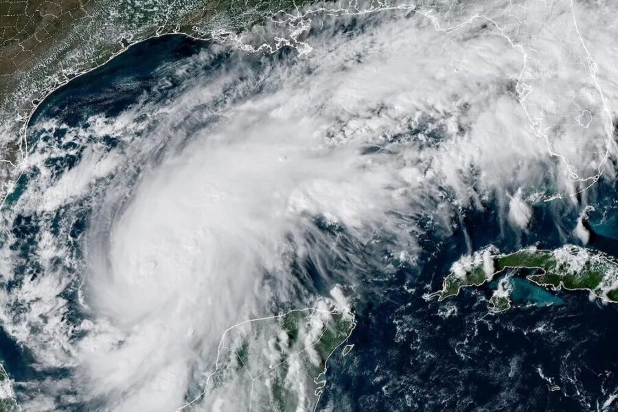
Hurricane Isaias threatened to knock out power and topple trees far beyond the Gulf Coast as the strengthening storm barreled toward an expected Friday evening landfall.
Coastal communities faced life-threatening storm surge, destructive winds and flooding rain, while forecasters warned that parts of the Southeast could take a beating well into the weekend.
The National Hurricane Center urged residents in hurricane warning areas to have preparations “rushed to completion today” as Isaias gained strength Thursday.
At 11 a.m. Eastern time, the Category 1 hurricane packed maximum sustained winds of 85 mph and was centered 380 miles south of the mouth of the Mississippi River. It was moving east-northeast at 10 mph.
Forecasters expected Isaias to rapidly strengthen before reaching the coast between Pascagoula, Mississippi, and Panama City Beach, Florida, on Friday evening. Winds could climb above 100 mph as the storm approaches the United States.
The hurricane was forecast to reach its peak strength before landfall and then weaken sharply. That would still leave coastal communities facing a dangerous storm.
“Regardless, Isaias is expected to remain a dangerous hurricane through landfall, and gusty winds are expected well inland after landfall…” the hurricane center said in a Thursday morning forecast discussion.
Hurricane warnings stretched from Ocean Springs, Mississippi, to Florida’s Bay-Gulf county line. Those warnings mean hurricane conditions are expected. Alerts for storm surge, flooding and high winds covered more than 400 miles of coastline, from southeastern Louisiana to the Florida coast south of Tallahassee.
POLL: Should ABC Pull The Plug On “The View”?
The threat extends well beyond the point where Hurricane Isaias comes ashore.
Much of Alabama and eastern Mississippi could see gusts of 50 to 60 mph Friday night into Saturday morning, meteorologist Matt Lanza wrote in his Substack, “The Eyewall.”
“This is likely enough wind to cause some widespread power line issues,” he said.
WPLG-TV hurricane specialist Michael Lowry warned that “gusty, damaging winds will extend well inland across Alabama, Mississippi, North Georgia, and the southern Appalachians during the day Saturday as the storm grows in size and accelerates through the southeast U.S.,” in a Thursday morning post on his Substack, “Eye on the Tropics.”
MORE IN WEATHER: Ex-Climate Reporter Blows Whistle, Reveals News Outlets’ Sinister Green Strategy
“This could lead to downed trees and widespread power outages this weekend,” he said.
Lowry stressed that “the impacts from Isaias will be felt hundreds of miles away from where the center comes ashore, especially to the east of its track, as increasingly strong upper-level winds from the west smear its heavy rain shield and expand its wind field inland.”
Isaias became the Atlantic’s first hurricane of the 2026 season late Wednesday, less than 20 hours after reaching tropical storm strength. The hurricane center announced at 11:30 p.m. Eastern time that its sustained winds had reached 75 mph.
If the forecast holds, Isaias would be the first hurricane to strike the United States since Hurricane Milton in 2024.
POLL: Should Trump’s DOJ Prosecute Jack Smith?
Continue reading...
[ H/T Trending Politics ]