




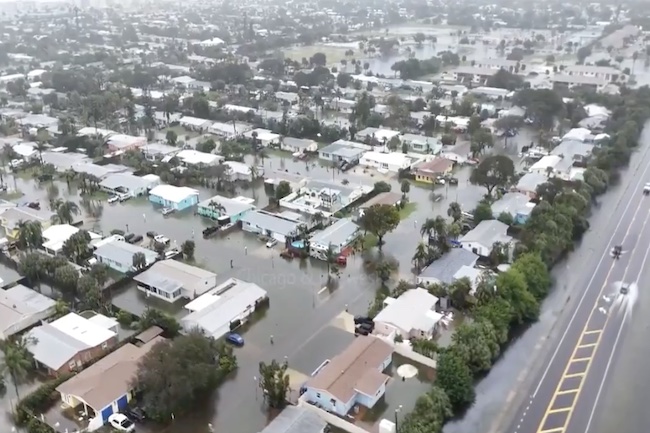
Heavy rainfall continued to produce widespread flooding across portions of Florida’s Atlantic coast on Thursday, particularly in Broward, Miami-Dade, and Brevard counties. Parts of Broward County, including areas around Fort Lauderdale and Hollywood, recorded more than 15 inches of rain since Tuesday, with some locations receiving up to a foot or more.
Plantation reported 16.4 inches, Hollywood 13.8 inches, and Fort Lauderdale 12.2 inches in recent days, while Fort Lauderdale-Hollywood International Airport had tallied nearly 17 inches over two days by Thursday morning, according to preliminary National Weather Service figures. A downpour ending early Wednesday in Fort Lauderdale produced 5.72 inches, breaking the previous daily record of 1.8 inches set in 1959.
Melbourne has accumulated more than 17 inches this month, nearly doubling its prior November record, while Fort Lauderdale has also exceeded its previous wettest November and autumn totals.
In Brevard County along the Space Coast, rainfall of 6 to 10 inches fell in areas including Rockledge and Merritt Island, with an additional 3 to 8 inches possible through Friday in some pockets. The St. Johns River near Cocoa reached a record level of approximately 18.1 to 18.2 feet on Thursday morning, surpassing the previous high of 17.55 to 17.6 feet set in October 1953.
The river was forecast to crest near 18.4 feet later in the day, with water already affecting low-lying neighborhoods in Cocoa, Rockledge, and Palm Bay.
Impacts included school closures on Thursday in Broward, Miami-Dade, and Brevard counties, along with some facilities in Indian River and Volusia counties. Palm Bay officials issued a mix of mandatory and voluntary evacuations for certain neighborhoods and arranged boat transport for residents.
Florida Fish and Wildlife Conservation Commission officers rescued more than 70 residents and 20 to 30 pets from a flooded Hollywood apartment complex on Wednesday. Roads such as sections of Interstate 95, the Florida Turnpike, U.S. 1, and State Road 520 were closed or covered by water, with vehicles stalled or partially submerged.
Flood watches remained in effect through Thursday evening in parts of southeast Florida and through Friday evening across most of east-central Florida. National Weather Service meteorologists indicated that saturated ground means further rainfall will produce additional runoff. “Any additional rainfall is going to become runoff,” said Cassie Wishard, a meteorologist with the National Weather Service Melbourne office.
The heavy rain was associated with a slow-moving low-pressure system influenced by El Niño conditions, which have interrupted the typical dry season. Additional rainfall of several inches was expected through Friday, with the heaviest amounts possible along the coast from roughly Port St. Lucie northward.
Rain was forecast to ease late Friday night into early Saturday as the system begins to move north. However, river flooding along the St. Johns near Cocoa is expected to continue for an extended period, with major flooding potentially lasting through December and at least minor flooding into January 2027 in some locations as runoff slowly drains through the basin.
No deaths or injuries had been widely reported in connection with the current rainfall as of Thursday afternoon, though earlier flooding this month had been associated with fatalities.
Continue reading...
[ H/T Trending Politics ]